CivilGEO, Inc.
  • 产品
    • GeoHECHMS
    • GeoHECRAS
    • GeoHECRAS 2D
    • 客户故事
    • 成功案例
  • 定价
  • 培训
    • 培训课程
    • 培训网络研讨会
    • 产品教程
  • 支持
    • 获得支持
    • 知识库
    • 功能请求
  • 关于
    • 关于我们
    • 客户评论
    • 新闻资讯
    • 隐私中心
    • 博客
  • 联系我们
  • Chinese (中文)
  • Menu Menu

GeoHECRAS

联系我们 下载免费试用
GeoHECRAS

GeoHECRAS®

从多种数据源快速构建
HEC-RAS模型

    开始免费试用  下载文件
GeoHECRAS

GeoHECRAS®

从多种数据源快速构建
HEC-RAS模型
    开始免费试用
概述
概述

什么是GeoHECRAS?

GeoHECRAS显著加快HEC-RAS模型的创建和审核,产生更好更准确的结果。为稳定和不稳定流模型、桥涵公路口岸、FEMA河漫滩蚕食面、河流修复、内联水库结构和非河槽存储区域等计算水面线。

  • 易学
  • 直接上图工作
  • CAD与GIS集成

查看更多功能
系统要求

GeoHECRAS Overview Video

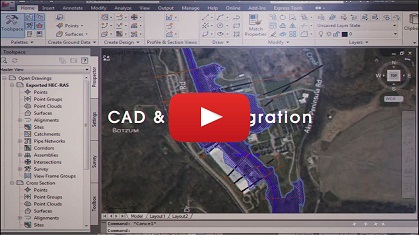
GeoHECRAS概述(视频01:23分钟)

使用自动化工作流更快地工作:

与HEC-RAS兼容的AutoCAD、MicroStation和ESRI ArcGIS图形界面

GeoHECRAS是一个与AutoCAD、MicroStation和ESRI ArcGIS兼容的交互式2D/3D图形用户界面数据包装器,适用于美国陆军工程兵部队HEC-RAS软件。

将各种不同的数据快速方便地导入HEC-RAS

导入现有的兵团HEC-RAS模型,并使用纳入的地理参考工具快速与现实世界的地图地理配准。

在多个HEC-RAS模型上同时工作

使用多文档接口(MDI),同在进行多个HEC-RAS项目,包括在HEC-RAS项目之间复制和粘贴截面和其他数据。

工作流
Integrate HEC-RAS directly with AutoCAD drawing files, Bentley MicroStation drawing files and ESRI ArcGIS map data. Export completed HEC-RAS models and results to AutoCAD (including AutoCAD Civil 3D and Map 3D), MicroStation and ESRI ArcGIS.

CAD和GIS的集成

将HEC-RAS与AutoCAD绘图文件、Bentley MicroStation绘图文件和ESRI ArcGIS地图数据直接集成。

Shift seamlessly between 2D and 3D viewing perspectives to more clearly identify modeling issues and make changes. Freely rotate, pan, zoom, and fly through the model to any perspective to review cross sections, bridge structures, culverts, levees, ineffective flow areas, and more.

二维和三维视图和编辑

在2D和3D视图之间进行无缝转换,以更清楚地识别模型问题并进行更改。

Extract HEC-RAS cross sections from 3D digital elevation terrain data. Utilize AutoCAD Civil 3D surfaces, MicroStation surfaces, contours, TINs, DTMs, DEMs, survey points, LiDAR, and other external digital elevation terrain data.

数字地形截面切割

从三维数字地形高度数据提取
HEC-RAS横截面。

查看更多工作流程

了解工程师如何使用GeoHECRAS

banner-image-geohecras

CRAFTON TULL
“为什么HEC-RAS不这样做?”这是 Crafton Tull的Anna Negrete在开始使用GeoHECRAS
之前经常问的问题…
  视图

banner-image-geohecras

INTEGRATED ENGINEERING
Integrated Engineering PLLC的水资源和项目工程师描述了使用
GeoHECRAS后节省的大量的时间和成本
  视图

banner-image-geohecras

FTN ASSOCIATES
FTN Associates的Lee Beshoner解释说,利用GeoHECRAS,他可以高效地创建表面文件,并快速、有效地生成模型结果…
  视图

查看更多故事

功能
功能
Interact graphically with all HEC-RAS model elements. Effortlessly create and edit cross sections, bridge and culvert roadway crossings, ineffective flow areas and other model elements by clicking and dragging. Uncomplicated dialog boxes allow easy data entry and review.

易学易用

所有HEC-RAS
模型元素可进行图形交互。

Blend Google or Bing online maps and high-resolution aerial imagery files directly into the HEC-RAS model. Quickly and easily georeference existing HEC-RAS models to background maps, AutoCAD and MicroStation drawings, or ArcGIS map data.

直接上图工作

直接把谷歌或必应在线地图和高分辨率航
空影像文件融合到HEC-RAS模型。

Integrate HEC-RAS directly with AutoCAD drawing files, Bentley MicroStation drawing files and ESRI ArcGIS map data. Export completed HEC-RAS models and results to AutoCAD (including AutoCAD Civil 3D and Map 3D), MicroStation and ESRI ArcGIS.

CAD与GIS集成

将HEC-RAS与AutoCAD绘图文件、Bentley MicroStation绘图文件和ESRI ArcGIS地图数据直接集成。

Extract HEC-RAS cross sections from 3D digital elevation terrain data. Utilize AutoCAD Civil 3D surfaces, MicroStation surfaces, contours, TINs, DTMs, DEMs, survey points, LiDAR, and other external digital elevation terrain data.

数字地形截面切割

从三维数字地形高度数据提取HEC-RAS
横截面。

Generate floodplain and floodway mapping from HEC-RAS results and 3D digital elevation terrain data. Export results directly to AutoCAD (including AutoCAD Civil 3D and Map 3D), Bentley MicroStation, and ESRI ArcGIS, as well as publish to PDF.

河漫滩及分洪道制图

从HEC-RAS结果和三维数字高程地形数据生
成河漫滩和洪道地图。

Quickly build 1D and 2D HEC-RAS models using the provided CAD/GIS tools that are integrated within an easy to understand user interface. Perform 1D steady flow and unsteady flow modeling, 2D unsteady flow modeling and combined 1D and 2D unsteady flow modeling. Complex 2D modeling, such as 2D bridge modeling and 2D dam breach modeling, can be handled with ease.

一维和二维流动模型

使用提供的CAD/GIS工具快速建立一维和二维
HEC-RAS模型。

Create either rectangular or adaptive meshes, depending upon the project requirements. Quickly insert obstructions—such as bridge piers, bridge abutments, and flow training structures—to model complex 2D modeling conditions. Quickly modify 2D flow area mesh elements using the provided mesh editing tools. Generate and merge terrain elevation surfaces from multiple sources, such as LiDAR, bathymetric survey, surveyed cross sections, elevation grids, TINs and more.

二维网格生成与细化

根据项目要求创建矩形或自适应网格。

Complete land use coverage is provided for the USA at an approximate 100 x 100-foot grid cell size. This makes it extremely easy to assign Manning’s roughness values to the HEC-RAS model.

包括土地使用覆盖范围

为美国提供约100 x 100英尺网格单元
大小的完整土地使用覆盖。

Define bank stations, flow lengths, ineffective flow areas, conveyance obstructions, levees and other riverine modeling data from CAD and GIS data. Assign cross section Manning’s roughness using GIS polygons or orthophoto base map image processing.

自动GIS制图功能

定义堤岸站、水流长度、无效水流区、运输障碍物、堤防和其他数据。

Utilize world-wide high resolution 3D digital elevation terrain data from map services for automated cross section extraction and creation of flood maps. Utilize web-based mapping services for aerial orthophotos, FEMA flood maps, watershed delineation, river centerline alignment, and more.

基于云的地图服务

利用来自地图服务的世界
范围内的高分辨率三维数字高程地形数据。

Shift seamlessly between 2D and 3D viewing perspectives to more clearly identify modeling issues and make changes. Freely rotate, pan, zoom, and fly through the model to any perspective to review cross sections, bridge structures, culverts, levees, ineffective flow areas, and more.

二维和三维视图和编辑

在2D和3D视图之间进行无缝转换,以更清楚地识别模型问题并进行更改。

Load, edit, and run multiple HEC-RAS models simultaneously. The Multiple Document Interface (MDI) allows easy copying and pasting between models, quick comparisons of input data and results between scenarios, and other modeling efficiencies. Models can be displayed in tiled windows or tabbed views, providing greater productivity.

MDI多模型编辑

同时加载、编辑和运行多个HEC-RAS模型。

Reduce time wasted with imprecise data. Easily integrate field collected data in varying formats along with CAD and GIS data to update the HEC-RAS model to accurately reflect field conditions.

更精确的模型

减少因数据不精确而浪费的时间。以不同格式轻松集成现场收集的数据。

HEC-RAS specific tools offer a more efficient way to create and analyze rivers, streams, bridges, culverts, inline structures, and more. Define cross sections that dynamically update as terrain data is changed. Quickly define levees, ineffective flow areas, conveyance obstructions, roughness subareas using specialized HEC-RAS tools.

特定HEC-RAS工具

HEC-RAS特定工具提供了
一种更有效的方法来创建
和分析河流、溪流、桥梁、涵洞、内联结构等等。

Create stunning visualizations directly from the software of different design alternatives to help better understand the impact of the design on the community and the surrounding environment. Publish the HEC-RAS model directly to Google Earth for even greater visualization and understanding of the project.

令人惊叹的视觉效果

直接从不同设计方案的软件中创建令人惊叹的可视化效果,以帮助更好地理解设计的影响

附加功能
附加功能
Compute HEC-RAS steady and unsteady flow results directly within the software, no external data processing required. Read and write standard US Army Corps HEC-RAS data files, ready for regulatory agency submittal.

全HEC-RAS模型支持

在软件内直接计算HEC-RAS
定常和非定常流动结果。

Correct mistakes easily with unlimited Undo and Redo capability. Experiment with different engineering and GIS decisions. Rollback changes one at a time or select a group of changes from a visual selection list.

无限撤消和重做

用无限的撤销和重做能力轻松纠正错误。

Toll-free unlimited technical support by experienced HEC-RAS modelers is just a phone call away. Quickly resolve your HEC-RAS modeling questions and complete your engineering projects on time—our skilled, professional engineers are here to assist you.

专家技术支持

由经验丰富的HEC-RAS建模师提供的免费、无限的技术支持只需打个电话。我们的技术支持团队周一至周五全天 24 小时提供。

Handle larger projects with powerful 64-bit, multi-core, parallel processing support. This improves performance and stability for memory-intensive tasks—including running HEC-RAS simulations faster.

强大的64位多核支持

使用强大的64位、多核、并行处理支持轻松处理较大的项目。

Complete HEC-RAS reporting is provided, including cross section plots, cross section tables, profile plots, profile tables, time series graphs, and more. Because the report data is derived directly from the HEC-RAS model, reports can easily be updated, providing quicker feedback as changes are made.

完整的报告

提供了完整的HEC-RAS报告,包括横截面图、横截面表、剖面图、剖面表等。

Compare different engineering models, such as existing and proposed bridges, river realignments and restorations, floodplain encroachments, and more. This capability allows stakeholders to evaluate alternatives, allowing you to consider more innovative and environmentally sensitive designs.

假设情景管理分析

比较不同的工程模型,如现有的和拟建的桥梁,河流的重新调整和修复,等等。

客户故事
客户故事

banner-image-geohecras

CRAFTON TULL
“为什么HEC-RAS不这样做?”
这是Crafton Tull的Anna Negrete
在开始使用GeoHECRAS之前经常问
的问题…
  查看

banner-image-geohecras

INTEGRATED ENGINEERING
Integrated Engineering PLLC的水资源和项目工程师描述了使用
GeoHECRAS后节省的大量的时间和成本
  查看

banner-image-geohecras

FTN ASSOCIATES
FTN Associates的Lee Beshoner解释说,利用GeoHECRAS,他可以高效地创建地表文件,并快速、有效地生成模型结果…
  查看

banner-image-geohecras

BOLTON & MENK
Bolton & Menk公司工程师称赞
GeoHECRAS的能力,将编辑功能、
模型操作和输出结合在一个集成的包…
  查看

banner-image-geohecras

LJA ENGINEERING
LJA Engineering在转换到
GeoHECRAS之前,多年来一直在努力将
AutoCAD在表面坐标系中的测量信息与
GIS坐标系进行匹配
  查看

banner-image-geohecras

THOUVENOT, WADE & MOERCHEN
Thouvenot,Wade & Moerchen
的工程师赞扬GeoHECRAS的场
景管理器工具,快速建立水力学模型
的表面几何形状的能力,和…
  查看

banner-image-geohecras

THE H.L. TURNER GROUP INC.
H.L.Turner Group, Inc.的工程师观察到,在使用
GeoHECRAS之前,为模型创建几何文
件所需的时间很长,并且可能会…
  查看

banner-image-geohecras

LYON ENGINEERING
Lyon Engineering公司的
Brian Bucholtz强调GeoHECRAS
软件是如何将所有东西“整合在一
起”的,并允许他无缝地输入数据
和项目…
  查看

banner-image-geohecras

MORRISON MAIERLE
Morrison Maierle的水资
源工程师讨论了他们使用GeoHECRAS
非常有效地调整河流模型几何形状
的能力…
  查看

banner-image-geohecras

ILIFA AFRICA ENGINEERS
一家广泛从事河漫滩划定工作的工程和土
地测量公司赞赏GeoHECRAS将基础信
息集中在一起…
  查看

banner-image-geohecras

JE FULLER
JE Fuller负责世界各地以及美国
的排水项目,拥有40多年经验
的工程师Chris Rod赞赏GeoHECRAS
独立运行…
  查看

banner-image-geohecras

GRUPPE WASSER
在使用GeoHECRAS之前,土木工程师Marcus Prantl
很难创建精确的表面地形,也很难划定河段和桥梁…
  查看

banner-image-geohecras

BEPG
在法国南锡负责水力研究、结构设计和河漫滩管理研究的工程师
Denis Rouselle证实,在使用
GeoHECRAS之前…
  查看

banner-image-geohecras

BARBAGELATA INGENIERÍA S.A.
工程师Vanessa Gimenez
解释了她的公司很难为开发的许
多水文2D模型生成预处理和后
处理数据…
  查看

banner-image-geohecras

ARTELIA MADAGASCAR
输入数据、运行彼此独立的程序,然后编辑输出,因此几乎没有时间来查看河流的结果…
  查看
成功案例
成功案例

BOLTON & MENK
Bolton & Menk公司工程师称赞
GeoHECRAS的能力,将编辑功能、模型操作和输出结合在一个集成包…
阅读更多

JE FULLER
JE Fuller负责世界各地以及美国
的排水项目,拥有40多年经验的工
程师Chris Rod赞赏GeoHECRAS独立运行…
阅读更多

banner-image-geohecras

FTN ASSOCIATES
FTN Associates的Lee Beshoner解释说,利用GeoHECRAS,他可以高效地创建表面文件,并快速、有效地生成模型结果…
阅读更多

KIMLEY-HORN AND ASSOCIATES, INC.
与Kimley-Horn历史上使用的传统
USACE HEC-RAS软件不同,GeoHECRAS表面的使用….
阅读更多

KPA ENGINEERS
在使用GeoHECRAS
之前,KPA工程师必须在各种
CAD和GIS程序以及美国陆军工程兵
团(USACOE)之间来回切换)…
阅读更多

STORMWATER MANAGEMENT CONSULTING
使用地质岩进行洪泛区划定也节省了
大量时间和成本。Skupien指出….
阅读更多

AQUAFOR BEECH LTD
GeoHECRAS与GIS和其他应用程序(如PCSWMM)的兼容性使得前处理和后处理方面….
阅读更多
奖项与表彰
Captera Ratings G2 Crowd Ratings Momentum Leader G2 Badge Best Relationship Best Support Users Love Us Digital Award
联系我们的WhatsApp在

联系我们的WhatsApp在

CivilGEO评论

4.8/5分, 在G2网站上有150多条评论

review-ratings

GeoHECRAS是公认的顶级土木工程设计软件,在G2网站上超过150多个真实用户的评价中,平均评分为4.8分(满分5分.

civil-engineer-leader civil-engineer-quality-support civil-engineer-momentumleader
联系我们的WhatsApp在Reach us on WhatsApp
Review Us on G2Crowd 阅读评论
Autodesk Authorized Developer View Civilgeo profile on Ariba Discovery

产品介绍

  • 免费试用
  • GeoHECHMS
  • GeoHECRAS
  • GeoHECRAS 2D
  • 客户故事
  • 成功案例

公司简介

  • 关于我们
  • 客户评论
  • 联系我们
  • 隐私中心
  • 使用条款

支持

  • 知识库
  • 一般反馈
  • 联系支持
  • 功能请求

培训

  • 培训课程
  • 培训网络研讨会
  • 产品教程

联系我们

1-800-301-02-955
608-729-5100
 (US and Canada)

[email protected]
+1 608-729-5100


通过以下媒介关注我们


CivilGEO China
6/F, Office Tower C
Chamtime Plaza Lane 2889
No.3, Jinke Road
Pudong New District
Shanghai, 201203

CivilGEO Taiwan
11/F, No.1, Taipei Walsin Xinyi
Songzhi Road, Xinyi Dist.
Taipei City, Taipei, 11047
Taiwan

版权 © 2023 CivilGEO, Inc. 版权所有。

我们使用cookie为您提供最佳的在线体验。同意您接受根据我们的cookie政策使用cookie。

我接受 我的偏好 我拒绝
隐私中心 隐私设置 Cookie政策
Privacy Settings saved!
CivilGEO, Inc.
Privacy Settings

When you visit any web site, it may store or retrieve information on your browser, mostly in the form of cookies. Control your personal Cookie Services here.

Necessary Preferences Analytics Marketing Privacy Center Privacy Policy Cookie Policy
These cookies are necessary for the website to function and cannot be switched off in our systems.

Technical Cookies
In order to use this website we use the following technically required cookies
  • wordpress_test_cookie
  • wordpress_logged_in_
  • wordpress_sec

Cloudflare
For perfomance reasons we use Cloudflare as a CDN network. This saves a cookie "__cfduid" to apply security settings on a per-client basis. This cookie is strictly necessary for Cloudflare's security features and cannot be turned off.
  • __cfduid

Preference cookies enable a website to remember information that changes the way the website behaves or looks, like your preferred language or the region that you are in.

FreshChat
We provide chat facility for users to come and chat with us to help resolve their issues.

These cookies allow us to count visits and traffic sources, so we can measure and improve the performance of our site.

Google Analytics
We track anonymized user information to improve our website.
  • _ga
  • _gid
  • _gat

These cookies are set through our site by our advertising partners.

LinkedIn
  • bscookie
  • AnalyticsSyncHistory
  • lissc
  • lidc
  • bcookie
  • lang
  • UserMatchHistor

Decline all Services
Accept all Services