 电话联系我们
电话联系我们
电话联系我们


易于学习和使用
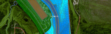
以图形方式与所有
HEC-RAS/HEC-HMS 模型元素交互

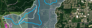
直接在地图上工作
将谷歌地图和高分辨率航
空图像文件直接混合到
HEC-RAS/HEC-HMS 模型中。

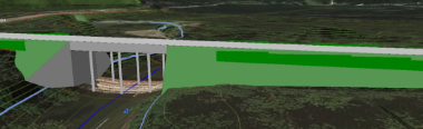
CAD与GIS集成
直接集成HEC-RAS/HEC-HMS
使用AutoCAD图形文件,
Bentley MicroStation和ESRI ArcGIS


不要只相信我们的话
看看为什么成千上万的工程师使用我们的产品,并高度推荐他们。

"优秀的HEC-RAS接口,具有激光雷达处理能力和强大的技术服务。"

"非常方便用户,技术支持也非常出色。"
"该软件大大缩短了标准HEC-RAS软件的设计时间"

奖励和表彰


联系我们的WhatsApp在
联系我们的WhatsApp在
CivilGEO在新的G2 Grid®工程软件报告中名列前茅
利用GeoHECRAS和GeoHECHMS先进而直观的工作流程,在一半的时间内完成您的工程项目。

CivilGEO评论
4.8/5.0分, 在G2网站上有230多条评论

GeoHECRAS是公认的顶级土木工程设计软件,在G2网站上超过230多个真实用户的评价中,平均评分为4.8分(满分5.0分.


联系我们的WhatsApp在


Close Popup
CivilGEO, Inc.
Privacy Settings
When you visit any web site, it may store or retrieve information on your browser, mostly in the form of cookies. Control your personal Cookie Services here.
These cookies are necessary for the website to function and cannot be switched off in our systems.
In order to use this website we use the following technically required cookies
For perfomance reasons we use Cloudflare as a CDN network. This saves a cookie "__cfduid" to apply security settings on a per-client basis. This cookie is strictly necessary for Cloudflare's security features and cannot be turned off.